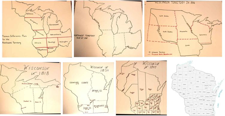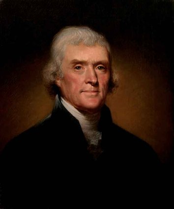
The new country was not yet 10 years old when Thomas Jefferson had his grand idea — the orderly westward expansion of the new country. In 1784, Jefferson proposed that the area north of the Ohio River and westward to the Mississippi be organized and divided into ten states, all with exotic names.
Jefferson was a brilliant, educated man. He was a man of the classics and was an architect — he liked his lines straight and his names classy. If Jefferson’s plan had been accepted, the citizens of southwest Wisconsin would now be living in the state of Michigania, or possibly Assenisipia, depending on the placement of the state line.
Jefferson’s plan was not followed completely but it did form the basis for the adoption of the Ordinance of 1787, creating the Northwest Territory. When Ohio became a state in 1803, the remainder of the area became Indiana Territory with the capitol at Vincennes, on the Wabash River. Indiana gained statehood in 1809.
What is now Wisconsin, Illinois, the upper peninsula and the portion of Minnesota east of the Mississippi became Illinois Territory with the capitol at Kaskaskia on the Kaskaskia River, which in 2010, boasted a population of 10. Michigan at that time was divided nearly equally between Indiana and Ohio. 1818 saw more changes as Illinois became a state. What was left of the old Northwest Territory became the Michigan Territory with the capitol at Detroit, with access to lakes Erie and Huron. Michigan had by then been detached from Indiana and Ohio.
Change was the one constant of the times, as, on April 20, 1836, President Andrew Jackson signed the bill creating Wisconsin Territory from a part of Michigan Territory as well as a large area laying west of the Mississippi that had been a part of the Louisiana Purchase. The Wisconsin Territory covered what is now Wisconsin, Iowa, Minnesota and the Dakotas as far west as the Missouri River.
Four months before Wisconsin Territory was established, the upper peninsula was removed from the proposed territory and given to the yet-to-be admitted state of Michigan in settlement of a border dispute with Ohio, known as the Toledo War.
The Illinois-Wisconsin border had been in a migratory state for some years. The original plan had it running straight across from the foot of Lake Michigan to the Mississippi River. This would have placed the mineral-rich Galena area, Chicago and the northern Illinois prairie-land in Wisconsin. Other lines were proposed further north than what now exists. People in that area did not know if they lived in Illinois or Michigan Territory. There is record of voters in the Shullsburg precinct casting ballots for Illinois legislators, and in 1828, the Jo Daviess County Board of Commissioners opened a voting precinct in Platteville. The line was finally fixed at 42 degrees, 30 minutes north latitude by Lucius Lyons in his survey of 1831.
President Jackson appointed his old army buddy and fellow Indigenous American fighter, Henry Dodge, as Territorial Governor. He was sworn in at a grand and raucous celebration held in Mineral Point on July 4, 1836.
No certain place had been designated as the Capitol when Wisconsin Territory was formed. Gov. Dodge selected Belmont, in the heart of the lead region. The first Territorial Legislature convened there on October 25, 1836, to work out the laws to govern the new territory. The session lasted 46 days, 42 laws were passed, among them, the establishment of territorial roads, the approval of building of bridges and ferry lines. Banks were chartered. A railroad from Mineral Point to Milwaukee was proposed that never saw the light of day. The University of Wisconsin-Belmont was established, but no money was appropriated for it.
Father Samuel Mazzuchelli, a man of many talents as well as a dedicated man of God, was invited by Gov. Dodge, and others, to address the first legislative session and to lead them in prayer for as long as he could stay. He remained in Belmont for one week, but his priestly duties were pressing and he could stay no longer.
One very important matter that led to much lively debate was the selection of a location of the permanent capital of the territory. Many people were dissatisfied with Gov. Dodge’s choice of Belmont.
He was quite taken aback by this — he had given the matter much thought and considered Belmont very suitable. It was midway between Galena and Mineral Point, the two main shipping and trade centers of the region. It lay close to several of the lead trails from Mineral Point to Galena. And it was easy to find, standing as it did at the foot of that beautiful mound which rises so clearly as a beacon and a sentinel over the surrounding countryside. He said, however, he would let the majority rule and approve any place they decided on.
Each day brought new proposals and motions with about eighteen towns wanting to be named capitol. Belmont would have liked it to remain there, but it was clear from the very beginning that was not to be. Mineral Point would have liked the title. It was already the county seat of Iowa County and the most important trading center of all the territory. Platteville was most anxious, but unsuccessful. Nelson Dewey and William Hamilton of Wiota pleaded long and hard for Cassville on the Mississippi, but were ignored. Milwaukee, Fond du Lac, Wisconsinapolis, and Peru, Dubuque and Burlington west of the Mississippi, were all brought forward, debated, and rejected, as well as several others.
Judge Doty arrived in Belmont on November 2, with his proposal to place the capitol at the Four Lakes. He owned many acres there and he gave parcels of land and buffalo robes to the legislators to win votes for that place for the capitol. It was an unusually cold autumn that year, with snow, bitter temperatures and biting winds. There is a distinct possibility that the buffalo robes did as much for the final outcome of the vote as did the free land. After much political maneuvering and many votes, Doty’s city of Madison, which consisted of nothing but plans on paper, was chosen as the permanent capital of the territory.
Gov. Dodge was very distressed at the manner of the proceedings. He said he wished he had never promised not to intervene. But being a man of his word, he let the decision stand. On December 3, 1836, he reluctantly signed the document establishing Madison as the capital of Wisconsin Territory. Judge Doty even had the temerity to offer Gov. Dodge some land. Gov. Dodge briskly informed him that when he desired land there he would buy it.
There was nothing there then. The lakes, of course, the wet-lands that go with them. The birds and animals of wilderness. There were a few Indigenous Americans (Indians) around. There was but one log cabin that was home to anyone. Because so much preparation was needed to prepare a suitable place for the Legislature to meet, and as a concession to the people of that area, Burlington, west of the Mississippi, was the selected location of the Legislative sessions of 1837. Iowa Territory was set off from Wisconsin Territory in 1838. The buildings in Madison were thought to be sufficiently completed to allow the Legislature to meet there, which it did, in November 1838.
All, however, was not ideal. The sap-filled boards, of which the seats and desks were constructed, made for damp, clammy sitting. The floor boards, of the same green lumber, shrank, leaving great, open cracks. The basement was not closed in and a drove of pigs took residence there. One legislator wrote that when one of his colleagues became too long-winded, he would stick a long pole through the cracks in the floor and stir up the pigs. Their squealing would soon cause the speaker to give up, with usually some choice words for the pigs, and probably for the one who provoked them. As late as 1840, members were so disillusioned with the progress of building construction they would have cheerfully moved the seat of government to another location, had they been able to agree on one.
Lewis Cass, Governor of Michigan Territory, in 1818 created the first counties in what is now Wisconsin. Crawford County covered the western part of the area with the county seat at Prairie du Chien on the Mississippi River. Brown County lay in the eastern portion, with the county seat at Camp Smith, located a couple of miles south of the Green Bay. Michilimackinac County lay across what is now the part of Minnesota east of the Mississippi, northern Wisconsin and the upper peninsula of Michigan, with the county seat at Mackinac Island.
Iowa County, consisting of the area south of the Wisconsin River, eastward from the Mississippi to a line straight south from Portage to the Illinois border, was set off from Crawford county in 1829. By 1834, Milwaukee County encompassed the southeast quadrant of the area, eastward from Iowa County to Lake Michigan, from the Illinois border northward to a boundary line from Portage eastward to Lake Michigan. The county seat was at Milwaukee, on Lake Michigan. Michilimackinac County had been completely eliminated and Crawford County extended all the way to Lake Superior. Brown County lay to the north of Milwaukee County with the county seat now at Green Bay, on the Green Bay of Lake Michigan.
When Iowa County was formed in 1829, the county seat was set at Helena, on the Wisconsin River, near present-day Spring Green. It was soon discovered there were not enough people in the area to make up a jury panel and the county seat was quickly moved to Mineral Point. It may be noted that up to this time, all the county seats and territorial capitals had been located on major water-ways.
Water was the rapid transit system of the times. Overland travel was, at best, difficult, and for the most part, impossible. A provision of the Northwest Ordinance specifically stated that the waterways were to be owned by no one, and should be forever open for the people to move about freely as they wished.
Grant County was separated from Iowa County in 1836, A court house was built in Lancaster (near the geographical center of the new county), on land donated by Maj. G. M. Price. Grant County is one of the few counties that did not have a “county seat battle”.
Dane County, formed in 1936, from portions of Iowa and Brown counties, was named for Nathan Dane, who was one of the authors of the Ordinance of 1787. The county government was organized in 1838. (Wisconsin Historical Collection, Vol.I)
Green County was detached from Iowa County in 1836 because the inhabitants were averse to the supremacy of Iowa County authority. The area was without government or legal organization of any kind until 1838, when an act of Legislature was approved.
When the present boundaries of Green County were established, the name given the area was Richland. Objections were raised and the name Greene (with an “e” at the end) in honor of Gen. Greene, of Revolutionary War fame, was selected. A printer’s error inadvertently dropped the final “e” and that became the familiar usage.
The citizens had asked the Legislature to select a location for the county seat. However, every place the Legislature proposed was vigorously opposed by one faction or another. The Legislators finally gave up and told the people they would have to sort it out themselves. And then came the elections.
The first election for location of the county seat was held in May, 1839. The result was a tie between Monroe and Roscoe, located about 2 miles to the northeast. Another election was held in June. All but one of the known voters cast their ballots. After much thought, the absentee was sent for, supposedly, to help on the side of Roscoe. But again, ended in a tie. At the third election, a young man by the name of Porter was promised the gift of a braided hat if he could persuade some of the miners of Exeter to vote for Monroe. Attractive and highly prized hats were made by a Mrs. Rust. Young Porter did his work well and Monroe won the vote by a majority of several votes. (Southwestern Wisconsin: Old Crawford County. P. 641-42)
In 1841, the grand total of seven settlers of what is now Richland County, met for a “mass meeting” to petition the Legislature to be set apart from Crawford County. The Legislature granted their petition in 1842. The area was attached to Iowa County for electoral and judicial purposes until such time as population had grown enough to allow formation of their own government. A committee of three men from Iowa County were appointed to select a county seat. They chose Richmond, later called Orion. By 1850 population was sufficient to organize county government. The county seat was then moved to Richland Center amid the familiar conflicts and bickering that accompany such an action.
By 1847, the population had grown sufficiently to warrant the further division of Iowa County. It was proposed that the southern half be taken to make LaFayette county, in honor of the Marquis de LaFayette, a French general who fought faithfully and bravely with the colonists in the Revolutionary War. The northern half of the area was to be renamed Montgomery County. The southern half was named LaFayette county, the northern half retained the name of Iowa County.
A division of property between the counties was made to avoid future claims and lawsuits. In a document signed December 23, 1847, the Board of Commissioners of LaFayette County paid the Iowa County Board of Commissioners a sum of $750. By doing so, they relinquished any rights to Iowa County buildings or property and could not be held responsible for any debts or lawsuits incurred by Iowa County. In turn, Iowa County could not be held responsible for any debts or lawsuits incurred by LaFayette County. Deeper reasoning behind the transaction may have been that the Iowa County Board knew the State Legislature would soon make the division anyway, and felt it prudent to do the deed while they had some input into it, and also pick up the tidy sum of $750. Whether this practice was common in the creation of other counties is not known.
The division of Iowa County spelled the beginning of the end for Mineral Point as the county seat. With the southern half gone, Mineral Point was no longer near the geographical center of the area.
In a county seat battle so intense a twelve pound cannon was ordered for use in it, the county offices were moved to Dodgeville in 1860.
With the formation of LaFayette County came the question of where to locate the county seat. The county supervisors were authorized to buy land, at no more than $1.25 per acre, and establish the county seat at Avon, the geographical center of the new county, located about a mile south of where the old lead road crossed the Pecatonica River. Jameson Hamilton, an early settler who seemed to own land wherever he thought something was going to happen, started to survey the place and lay out a town. He built a couple of houses. Stone was ordered for a courthouse. Before the county seat could be established at Avon, an act of Legislature was passed stating that until suitable buildings were provided at Avon, county business would be conducted at a place to be selected by the commissioners. Shullsburg was selected for this purpose. There was great sentiment for this location anyway, as it was felt that county business could be conducted more conveniently and efficiently in the greater populated part of the county, rather than the geographical center. After numerous acts of Legislature, several votes by the people, and a couple of rounds of Supreme Court proceedings, the county seat was finally fixed in 1861, at neither Shullsburg nor Avon, but at Center, now known as Darlington, on the north side of the Pecatonica.
The move to statehood, which Gov. Dodge had begun as early as 1840, did not come easily. The mission was continued, unsuccessfully, by Gov. Doty during his tenure as Governor. Proposals for statehood were three times defeated by voters, mainly because people feared higher taxes under state government. With territorial status most of the bills were paid by Congress.
In April 1846, with Henry Dodge back at the helm, sentiments had changed. The electorate approved the motion for statehood by a 5-to-1 margin. A constitution was formulated and submitted to voters in April 1847. It was rejected, mainly because of several controversial proposals within it. One had to do with banking procedures; another proposal would give married women the right to own property; another would grant the right to vote to immigrant men who had filed for citizenship; and another would make voting rights for Blacks subject to referendum.
Another constitutional convention was called and the resulting document was approved by voters in March 1848. Taking what was learned from the previous failure, the banking procedures were revised; there was no mention of women’s property rights or Black suffrage; the right to vote went to white native-born men, Indigenous Americans who had been declared U.S. citizens, and to immigrant men who had applied for citizenship.
Wisconsin became the 30th state of the Union on May 29, 1848. There were 28 counties in the new state. Nelson Dewey of Cassville, in Grant County, was elected the first governor. The first session of the first Legislature of the State of Wisconsin convened on June 5, 1848.
In 1998, the 150th anniversary, the Sesquicentennial, of the State of Wisconsin was celebrated.
Southwest Wisconsin can take pride in the fact that it is where Wisconsin began with the meeting of the Territorial Legislature. The flood of immigrants to the lead mines brought families, built towns, formed governments and brought religion and education, thus creating the stability necessary for a successful society.
And, as in the very early days, the one constant is change. As the mines of the southwest faded, they were replaced with farms. In other parts of the state lumbering had its hey-day. Industry was developed. Major shipping ports were established to hasten the movement of Wisconsin products to world markets.
People of many ethnic threads continue to make up the tapestry of the citizenry.
Change is constant as populations which migrated to urban areas are now finding their way back to rural settings to retire or to raise their children in less stressful environments. The smallest of communities are now striving to bring industry and develop tourism.
The borders of life in today’s Wisconsin reach far beyond city, county and state lines.
BIBLIOGRAPHY:
Wisconsin Then and Now, State Historical Society, Aug. 1969.
Butterfield’s History of LaFayette County, 1881
History of Darlington, Southwest Wisconsin Regional Plan Commission, 1984
Wisconsin Lore and Legend, Lou and John Russell, 1981, 1982.
The Wisconsin Story, H. Russell Austin, 1948, 5 th printing, 1964.
Badger History: Wisconsin Territorial Days. State Historical Society, 1973.
Southwest Wisconsin; Old Crawford County, John H. Gregory, 1932; Vols 1&2.